When the India Meteorological Department issued its latest alert on November 24, 2025, it wasn’t just another weather bulletin—it was a red flag for millions. From the crowded streets of Mumbai to the misty hills of Jammu & Kashmir, a prolonged storm system is set to unleash heavy to very heavy rainfall across the country between November 25 and December 1, 2025. The IMD, under the leadership of Dr. M. Mohan Rao, Director General of Meteorology, is sounding alarms not just for rain, but for cascading disruptions: flooded roads, suspended school operations, stranded travelers, and dangerous sea conditions. And this isn’t just a storm—it’s a pattern, one that’s becoming harder to ignore.
Storms in the Making: From Arabian Sea to Bay of Bengal
The trouble began on November 1, 2025, when a depression formed over the east-central Arabian Sea, centered near 19.4°N and 69.6°E—roughly 340 kilometers west of Mumbai. The IMD immediately issued an orange alert for Gujarat’s coastal districts: Gir Somnath, Amreli, Bhavnagar, Bharuch, and Surat. Fishermen were told not to go out. The sea, they warned, was turning into a churning mess. By November 2, a second system had ignited over the Bay of Bengal, near Myanmar’s coast. This one wasn’t just a ripple—it was a slow-moving monster. The IMD predicted heavy rain for the Andaman & Nicobar Islands as early as November 2, and by November 5, the storm’s influence had stretched to Konkan and Goa, where thunderstorms rolled in with startling frequency. Lightning struck across Gujarat, while Marathwada and Madhya Maharashtra braced for repeated downpours.The Southern Deluge: Tamil Nadu Under Siege
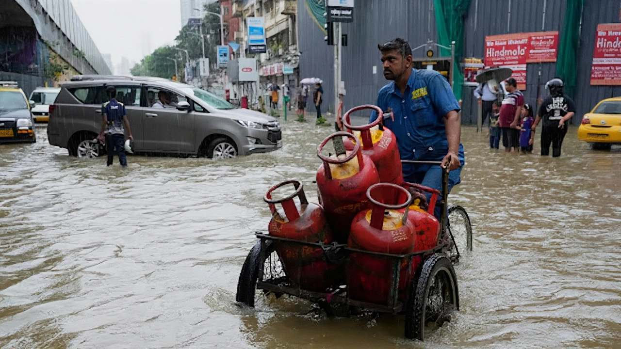
But the real crisis is unfolding in the south. Tamil Nadu is on track to receive what the IMD calls “very heavy rainfall” from November 28 to 30, 2025—following already intense showers on the 25th through 27th. The same pattern hit on November 16 and 18, when isolated pockets recorded extremely heavy rain, flooding streets in Chennai and Puducherry. Now, it’s happening again. And this time, the system is stronger. “Localised flooding, waterlogging, and temporary road closures are inevitable,” said an IMD spokesperson on November 24. Schools in Chennai and Bengaluru may shut down. Public transport could grind to a halt. Emergency services are already being repositioned.Northwest Chill and Western Disturbances
While the south drowns, the north freezes. A new Western Disturbance, the IMD warned, will slam into the Western Himalayas starting November 4, 2025. Jammu & Kashmir, Ladakh, and even Gilgit-Baltistan are bracing for thunderstorms with winds of 40–50 km/h. But the bigger shock? Temperatures could plunge below 6°C in isolated areas. That’s not just cold—it’s life-threatening for those without adequate heating. Rajasthan saw rain on November 3–4, Himachal Pradesh on the 4th–5th, and Uttarakhand on the 4th. Even Delhi-NCR might get a light drizzle. The contrast is jarring: one part of the country drowning, another freezing. “This November is shaping up to be a month of weather contradictions,” said Dr. Dharmaraju, an IMD climatologist. He pointed to La Niña—a cooling of Pacific Ocean waters—as the engine behind the chaos.Why This Matters Beyond the Rain
This isn’t just about umbrellas and raincoats. The IMD’s retrospective report from November 20, 2025, shows that isolated heavy rains in November have already damaged crops in Vidarbha and disrupted supply chains in Madhya Maharashtra. With Tamil Nadu producing nearly 10% of India’s rice and Kerala a major hub for spices and rubber, the economic ripple effects could be significant. Farmers in the south are already reporting standing water in paddy fields. Transport delays are piling up. And then there’s the human cost. In 2023, similar November rains in Tamil Nadu led to 47 fatalities from drowning and electrocution. This year, with urban drainage systems still struggling to recover from last season’s floods, the risk is higher. Emergency shelters in Coimbatore and Trichy are being readied. The government has activated the National Disaster Response Force in five states.What Comes Next
The IMD predicts the system will linger into early December, with heavy rain extending to coastal Andhra Pradesh, Yanam, and Rayalaseema from November 29 to December 1. The Andaman & Nicobar Islands will remain under watch until November 29. Meanwhile, the depression over the Strait of Malacca and the low-pressure zone over the southwest Bay of Bengal suggest this isn’t a one-off—it’s part of a larger, intensifying cycle. Climate scientists warn that La Niña’s influence, combined with rising sea surface temperatures in the Indian Ocean, is making monsoon remnants more unpredictable. What used to be a brief November shower is now a multi-day event with compound risks. The IMD has urged state governments to coordinate disaster plans—because waiting for the rain to stop is no longer an option.Frequently Asked Questions
How will this affect daily life in Chennai and Bengaluru?
Schools in Chennai and Bengaluru may close from November 28 to 30, 2025, due to severe waterlogging and flooding. Public transport, especially buses and suburban trains, could face major delays. The Chennai Metropolitan Water Supply and Sewerage Board has already reported 12 critical drainage choke points. Residents are advised to avoid low-lying areas and keep emergency kits ready.
Why is Tamil Nadu getting so much rain this November?
Tamil Nadu’s rainfall surge is linked to a persistent low-pressure system over the Bay of Bengal, amplified by La Niña conditions. These systems typically feed moisture from the ocean into the state’s coastal and interior regions. The IMD recorded 140% of normal rainfall in parts of the state during mid-November, and the pattern is intensifying, not fading.
Are fishermen really being told not to go out?
Yes. The IMD has issued no-fishing advisories across the Arabian Sea from Gujarat to Kerala and the Bay of Bengal from Tamil Nadu to Andhra Pradesh. Wave heights are forecast to reach 3–4 meters in some zones. Over 2,300 fishing boats were recalled to shore in Gujarat alone between November 1 and 5, 2025, and similar measures are being enforced in Tamil Nadu’s coastal districts.
What’s the connection between La Niña and this weather?
La Niña cools the equatorial Pacific, which shifts global wind patterns and strengthens the Indian monsoon’s lingering effects. This year, it’s causing more frequent and intense low-pressure systems over the Indian Ocean. The IMD says November 2025 rainfall is running 27% above average nationwide, with Tamil Nadu and Kerala seeing over 40% excess. This aligns with historical La Niña patterns from 2020 and 2022.
Could this lead to power outages?
Absolutely. The IMD has warned of lightning strikes in 12 states, which can damage transformers and transmission lines. In 2023, over 1,800 power outages were linked to November storms in Tamil Nadu and Kerala. Power utilities are now deploying mobile repair teams in high-risk zones like Coimbatore, Madurai, and Thiruvananthapuram.
Is this unusual for November?
Yes. November is typically a dry month in most of India, with rainfall dropping sharply after the monsoon retreats. But over the past five years, November rainfall has increased by 18% on average, especially in southern and eastern regions. The IMD’s 2025 forecast is among the most extreme since 2018, when similar conditions caused floods in Andhra Pradesh and Odisha.